Every two years a group of PhD students disappear into the geological wilderness for the RSES Student Field Trip. In 2014, students spent two weeks camping in the Australian outback investigating the regional geology of Central Australia. After many discussions and presentations about exotic and tropical locations, the student cohort settled on a geological road trip around Tasmania. Here is a quick overview of the geological history of Tasmania and some of the cool sites we managed to visit.
Our interactive map of the Tasmania route with the key geological locations
Although it contains the world’s biggest exposure of dolerite (covering most of the island), Tasmania also has a quite complex geological history.

The north west corner of Tasmania contains some of the oldest rocks (Precambrian), a sedimentary sequence which has been strongly folded and metamorphosed. It was during this time that Tasmania was still linked to an area of ancient North America rather than mainland Australia.
During the late Precambrian, Tasmania was located slightly north of the equator surrounded by shallow tropical seas. These conditions led to the precipitation of carbonate sediments which were later infused with magnesium-enriched waters forming the Hastings dolomite in south-east Tasmania. The dolomite was capped by a Permian tillite, protecting the dolomite during several glacial periods and only allowing erosion by solution, so it was around 300 mya that the caves began to develop as small cavities. Since the last interglacial periods (~130 000 years ago) there has been rapid formation and growth of speleothems.


Early in the Cambrian period, an oceanic arc collided with the entire east coast of Australia, leading to a deep oceanic crust being thrust over the top of the Precambrian rocks and leaving behind several ultramafic complexes. Serpentine Hill Quarry is a good exposure of the early Cambrian ultramafic rocks, remnants of the thurst-emplaced, dismembered ophiolitic sequences that were originally mostly periodites and pyroxneites but now largely altered to serpentinite.

Western Tasmania also contains the Mount Read Volcanics, consisting of submarine lavas, volcanic ash and shallow seafloor sediments. The Mount Read Volcanics are a 200 km long and 20 km wide belt of rocks containing several large ore deposits, currently mined for copper, lead, zinc and silver.

Granites intruded into east Tasmania around 400 million years ago. Whilst Devonian granitoids underly most of north east Tasmania at great depth, there are some spectacular outcrops along the east coast, including the Bay of Fires and Freycinet Peninsula. The Bay of Fires is famous for its orange lichen-covered granite boulders and white sandy beaches formed due of the high quartz content of the granites, which has eroded into a very pure white sand. The Freycinet Peninsula, home to Wineglass Bay and the Hazards, is made up of a orthoclase-rich granite which gives the mountains and coastline a characteristic pink tint.
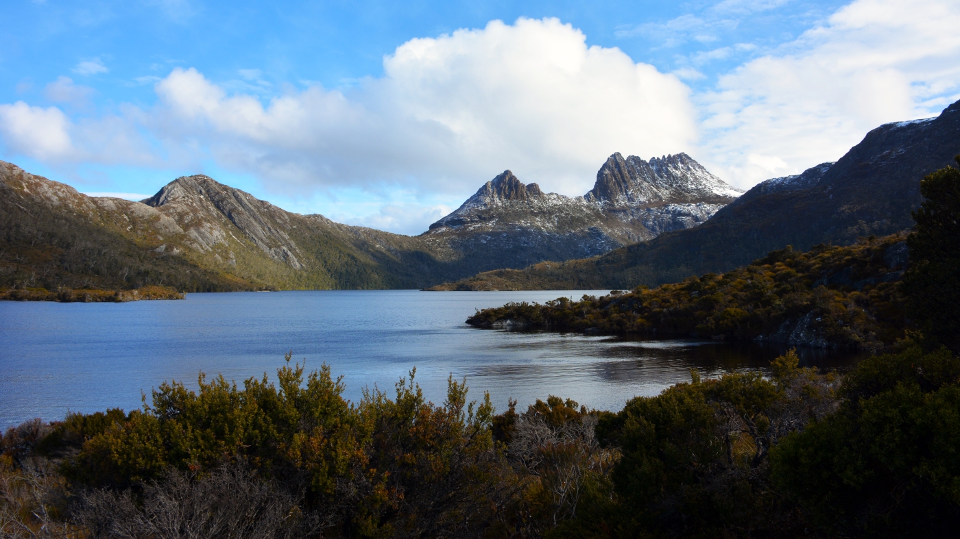
183 million years ago, during the Jurassic, a major intrusion of dolerite occurred and covered over one third of Tasmania (the fourth largest known magma intrusion in the world). Around 3 to 5 million cubic kilometres of magma were intruded, mostly in the form of sills up to 500m thick. Tasmania is home to the largest exposure of dolerite in the world (30 000 km2) and dolerite is referred to as the ‘rock that made Tasmania’. The most spectacular exposures of dolerite in Tasmania include Mt Wellington (overlooking Hobart), Cataract Gorge, the Tasman Peninsular and Cradle Mountain.
A series of volcanic vents opened up 58 to 8 million years ago, releasing lava flows of basalt across parts of Tasmania. In the north west Tasmania, there was so much lava that valleys filled and overflowed creating 750 metre thick plain of basalt. Dip Falls is a cascade waterfall that flows over cubic basalt columns which formed during the cooling of the extensive lava flow. Other examples of the volcanic vents in the north west include the Table Cape and Stanley volcanic plugs.
Throughout the Quaternary, glaciation occurred across Tasmania making it one of the few southern hemisphere locations to contain glacial landforms. The ice cap on the Central Plateau is responsible for eroding much of the Tasmanian highlands, including Lake St Clair and Cradle Mountain. Lake St Clair was scoured out by glacial action over two million years and is the deepest freshwater lake in Australia with a maximum depth of 167 metres. Cradle Mountain, consisting of a solid chunk of dolerite that withstood the glaciation, stands behind Dove Lake, one of the many U-shaped glacial lakes eroded out of the bedrock.


Leave a comment